I went on a fun 100-mile ride three days ago -- Boulder to Lyons to Estes Park, past Raymond and Ward to Nederland and then back down to Boulder. The 20 miles from Lyons to Estes Park included a 15-mile climb and a 4-mile descent, then it was another 30 mostly-uphill miles to Ward. I started at 5430 feet of elevation but spent more than half the ride about 7500 feet. I wasn't always putting out a lot of power but the effort level was there, and I felt surprisingly zippy when I swam "down" at 5430 feet that night.
I found that somebody else uploaded this route to Bikely but they went counterclockwise while I went clockwise. I also found it on Map My Ride but that rider started in Nederland. Here is the elevation profile from that starting point. I like to think of miles 30 to 80 on their map as a fifty-mile climb.

Now on to the photos...
Here is the only flat section between Lyons & Estes Park. You can see the peaks of Rocky Mountain National Park in the distance.

About to start the descent to Estes Park... Unfortunately I was going to fast to get a picture of the lake as I entered town. You'll have to check it out yourself some day. I had stayed dry so far but the sky looks ominous, eh?

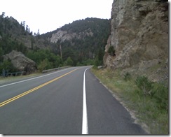
The lonely road to Ward... I've been sprinkled on a few times by now...
Finally, the summit! Why is it that the highest town I passed doesn't have an elevation on the welcome sign? Estes is at 7500 and Ned is at 8200 -- both are in valleys -- while Ward is at like 9200 feet.

Finally, here is a shot from just past Ward that captures the "edge of the world" feeling that you get up there. Someday I'll have to ride with a real camera instead of snapping pictures with my cell phone.

The sky opened up between Ward and Nederland, so I didn't take any more pictures. I took shelter in a convenience store in Ned and tried to warm up a bit before the final descent down Boulder Canyon to my Home Sweet Home Away from Home.
No comments:
Post a Comment